个人档案Profile地点地图Site Map研究主题Research Themes田野经历Fieldwork文物与资料Artifacts and Notes现场图库Field Gallery参考资料Sources
Site Survey and Surface Collection
← 返回田野经历← Back to fieldwork

Experience 01

遗址踏查与地表采集Site Survey and Surface Collection

以地貌观察、地表遗物采集和记录训练为核心,学习如何从零散材料建立对遗址范围、性质和保存状况的初步认识。A survey-centered experience focused on landform observation, surface collection, and the first interpretation of site extent, function, and preservation.

Experience 01

遗址踏查与地表采集Site Survey and Surface Collection

以地貌观察、地表遗物采集和记录训练为核心,学习如何从零散材料建立对遗址范围、性质和保存状况的初步认识。A survey-centered experience focused on landform observation, surface collection, and the first interpretation of site extent, function, and preservation.

个人田野记录Personal field record

重点收获Key takeaway

我学会让地表材料始终回到路线、位置、编号和保存状况,而不是只保留一张好看的照片。I learned to keep surface material connected to route, location, numbering, and preservation rather than retaining only a compelling photograph.

Site Survey and Surface Collection

案例记录Case record

我做了什么,以及我不能据此断言什么。What I did—and what I cannot claim from it.

01

从走过一片土地开始,而不是从“发现文物”开始Beginning with the landscape rather than the discovery of objects

这次踏查训练让我第一次把遗址理解为一个空间问题。沿路线观察地形、土色、植被、道路和现代扰动时,我逐渐发现,地表遗物不能脱离它所在的环境单独解释。陶片密集并不自动等于古代活动中心,低密度区域也不代表那里从未有人活动;地表可见度、耕作、冲刷和取土都会改变今天看到的分布。记录这些条件,比单纯统计捡到多少陶片更重要。This survey training was the first time I understood a site as a spatial problem. While following survey routes and observing landform, soil colour, vegetation, paths, and modern disturbance, I learned that surface finds cannot be interpreted apart from their setting. A concentration of sherds does not automatically mark the centre of ancient activity, and a low-density area does not prove that no activity occurred there. Visibility, farming, erosion, and soil removal all shape the distribution seen today. Recording those conditions matters more than simply counting how many sherds were collected.

02

编号工作改变了我对“资料”的理解Numbering changed how I understood archaeological data

在整理点位、照片和袋签时,我体会到一件材料是否有研究价值,很大程度上取决于它能否回到原来的记录关系中。一个陶片即使可以辨认器形,如果失去位置和编号,也很难用于讨论遗址范围或功能分区。反复核对并不是附属劳动,而是在保护材料与现场之间的联系。这种工作看起来缓慢,却是后续分类、绘图和解释能够成立的基础。While organising points, photographs, and bag labels, I realised that the research value of an object depends heavily on whether it can be returned to its original record. Even an identifiable sherd contributes little to questions of site extent or activity zones if its location and number are lost. Rechecking records is not secondary labour; it preserves the connection between material and place. The process is slow, but it is the basis on which later classification, mapping, and interpretation depend.

03

这次经历能证明的是方法训练,而不是独立研究成果What this experience demonstrates is methodological training, not an independent research result

我把这段经历写入作品集,是为了说明自己接受过基础观察和记录训练,而不是声称已经独立判断遗址性质。路线设计、采集策略、陶片年代和遗址边界都需要由有经验的考古人员结合更完整的资料确认。对我而言,最真实的收获是开始知道哪些现象值得记录、哪些判断不能仓促作出,以及为什么承认资料的不完整性也是考古方法的一部分。I include this experience to show that I received basic training in observation and recording, not to claim that I independently determined the character of a site. Survey design, collection strategy, ceramic dating, and site boundaries require experienced archaeologists and fuller evidence. My most important gain was learning which conditions need to be recorded, which judgments should not be made quickly, and why acknowledging incomplete evidence is itself part of archaeological method.

7 篇日记7 Daily Entries

Day 1熟悉区域与任务分工Orientation and Team Roles+

上午听取带队老师介绍遗址背景、踏查范围和安全要求,下午查看地形图并分配记录、摄影、测量和采集职责。第一次把书本里的“遗址”放到真实地貌中理解,意识到考古工作首先是对环境的耐心阅读。In the morning, the instructor introduced the site background, survey area, and safety rules. In the afternoon, we studied maps and divided roles for recording, photography, measuring, and collection. I began to understand a site as a real landscape rather than a textbook category.

Day 2地貌观察与路线规划Landform Reading and Route Planning+

沿河谷和台地边缘步行,记录坡度、土壤颜色、植被变化和可见扰动。晚上整理路线,发现遗物往往和水源、台地、道路等因素一起出现,踏查不是随意走动,而是带着问题寻找证据。We walked along the valley and terrace edge, recording slope, soil color, vegetation, and disturbance. During evening review, I saw how artifacts often appeared together with water, terraces, and paths. Survey is not wandering; it is question-driven observation.

Day 3地表陶片采集Collecting Surface Sherds+

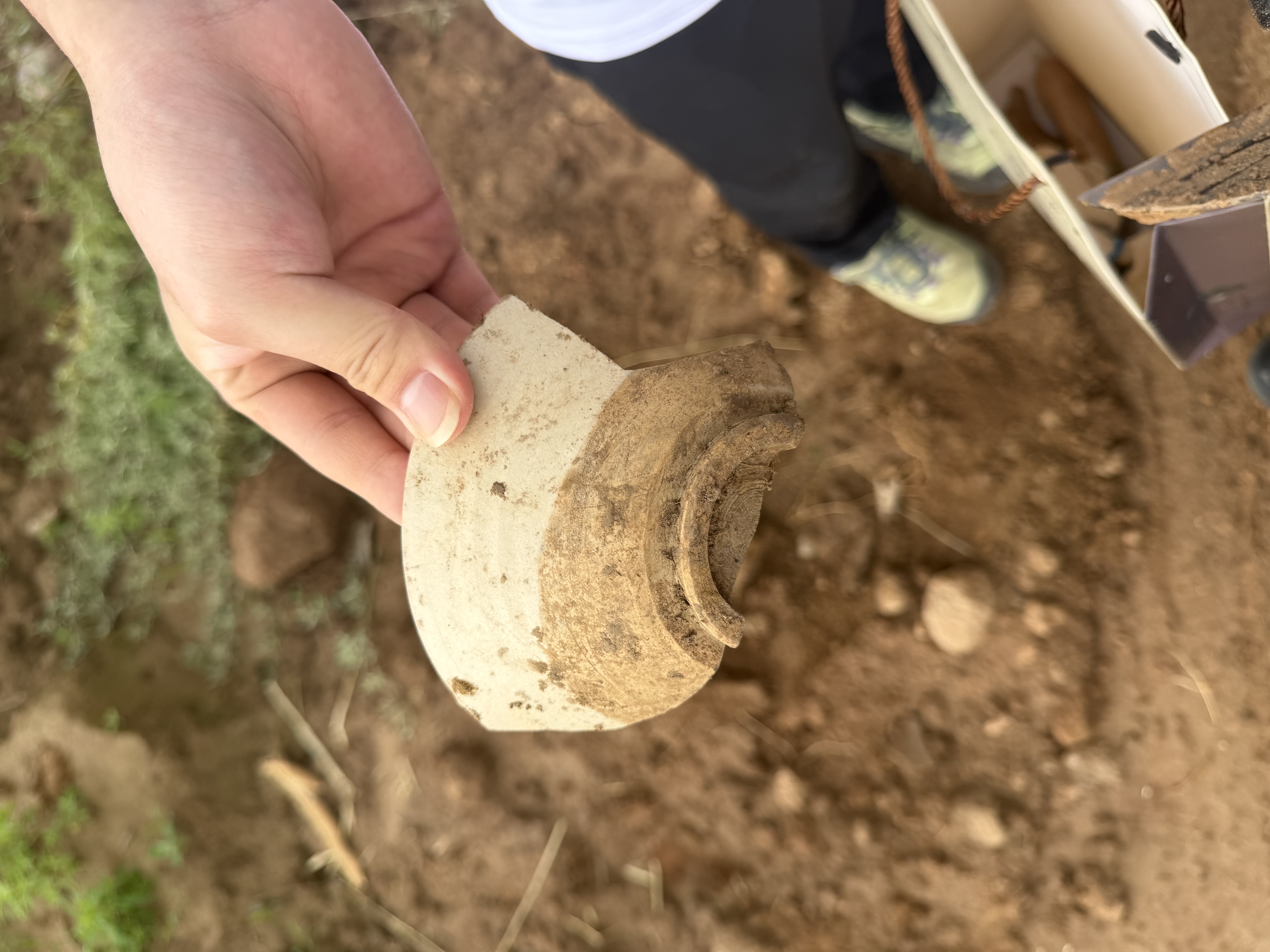
今天重点采集地表陶片,按网格记录位置、数量和可识别特征。口沿、腹片、圈足看似普通,却能提示器类和年代。清洗前先保留附着土,避免破坏可能有用的信息。We focused on surface sherds, recording location, quantity, and identifiable features by grid. Rims, body sherds, and feet looked ordinary, but they suggested vessel type and date. We preserved adhering soil before cleaning to avoid losing information.

Day 4GPS 定位与编号GPS Points and Numbering+

学习用 GPS 记录采集点,并把点位编号、照片编号和袋签编号对应起来。最耗时间的不是发现遗物,而是让每一件材料都能回到它的位置;没有位置信息,遗物就会失去大半解释力。We learned to record collection points with GPS and connect point numbers, photo numbers, and bag labels. The hardest part was not finding artifacts, but making each object traceable to its place. Without location, interpretation loses much of its strength.

Day 5辨认扰动与现代堆积Disturbance and Modern Deposits+

今天观察耕作、修路和取土造成的扰动。老师提醒我们不能把所有露出的陶片都等同于原生堆积。我开始学会区分原始位置、搬运堆积和现代混杂,这对判断遗址保存状况很重要。We examined disturbance from farming, road repair, and soil extraction. The instructor warned us not to treat every visible sherd as primary deposition. I learned to distinguish original context, redeposited material, and modern mixing.

Day 6采集袋整理与初步分类Bag Sorting and Initial Classification+

室内整理前几天的采集袋,按陶质、颜色、器壁厚度和部位进行初分。反复核对袋签让我明白,资料整理也是田野工作的一部分,而且常常决定后续分析是否可靠。Indoors, we sorted collected bags by fabric, color, wall thickness, and vessel part. Rechecking labels made me realize that data organization is fieldwork too, and it often determines whether later analysis can be trusted.

Day 7绘制踏查草图Sketch Mapping+

根据路线、点位和地形绘制踏查草图,标出遗物密集区和可能边界。地图让零散记录形成整体,也暴露出我们第一周路线中的空白区,提醒我调查设计需要不断修正。We sketched a survey map using routes, points, and landforms, marking artifact concentrations and possible boundaries. Mapping turned scattered notes into a pattern and revealed gaps in our first-week coverage.

学习成果总结论文Learning Essay

学习成果总结:从地表材料到遗址理解Learning Essay: From Surface Finds to Site Interpretation

一、踏查训练改变了我理解遗址的方式1. Survey changed how I understand a site

这次遗址踏查使我认识到,遗址不是地图上的一个点,也不是几件能够拍照展示的遗物,而是地貌、水源、现代扰动、材料分布和记录体系共同构成的空间问题。过去我更容易把考古想象成发掘和发现,但实际训练让我看到,发现之前还有大量判断:为什么走这条路线,为什么在这里停下,为什么这个陶片需要编号,为什么没有遗物的区域也要认真记录。This survey experience changed my understanding of a site. A site is not simply a point on a map or a few photogenic artifacts. It is a spatial problem formed by landform, water, disturbance, artifact distribution, and recording systems. Before discovery comes judgment: why this route, why this stop, why this sherd is numbered, and why areas without finds must also be recorded.

二、记录比发现更能决定资料价值2. Recording determines the value of finds

地表采集中最重要的经验,是每一件遗物都必须和位置、时间、采集者、照片、袋签和描述对应起来。陶片本身可以被清洗、分类和拍照,但如果丢失空间信息,它就很难说明遗址范围、功能区和形成过程。通过反复核对 GPS 点位、袋签和表格,我理解了考古学的严谨并不只体现在理论中,更体现在每一个编号是否能被追溯。The most important lesson in surface collection was that every object must connect to location, time, collector, photo, bag label, and description. A sherd can be washed and photographed, but without spatial information it says little about site extent, activity zones, or formation process. Checking GPS points, labels, and tables taught me that archaeological rigor lives in traceable details.

三、材料解释需要面对不完整性3. Interpretation must face incomplete evidence

踏查资料天然是不完整的。地表可见度、耕作、冲刷和现代建设都会影响遗物出现的位置和数量。学习过程中,我逐渐明白不能把采集结果直接等同于古代活动本身,而要先分析材料经过了哪些自然和人为过程。低密度区的记录尤其重要,因为它提醒我们遗址边界、保存状态和调查盲区同样是解释的一部分。Survey data is inherently incomplete. Visibility, farming, erosion, and modern construction affect where artifacts appear. I learned not to equate collected finds directly with ancient activity. Instead, formation processes must be considered first. Records from low-density areas matter because boundaries, preservation, and survey gaps are part of interpretation.

四、从资料整理到研究问题4. From data organization to research questions

室内整理让我看到,表格、照片和分布图不是附属工作,而是把现场资料转化为研究问题的关键步骤。当陶片类型、数量和位置被放在同一张图上,遗址内部差异才开始显现;当误差被修正,解释才有基础。这次经历让我学会在写作中先说明资料来源和限制,再讨论可能的遗址性质。Indoor organization showed me that tables, photos, and distribution maps are not secondary tasks; they transform field data into research questions. When artifact type, quantity, and location appear together, internal differences become visible. When errors are corrected, interpretation gains a foundation. I learned to discuss data sources and limits before proposing site function.

五、个人收获5. Personal gains

三周训练之后,我对考古方法的理解更加具体。考古不是简单地寻找古物,而是在有限证据中建立可检验的解释。踏查要求观察力、体力、合作和耐心,也要求承认不确定性。对我来说,这次经历最大的成果,是把“遗物”重新放回“地点”,把“地点”放回“问题”,并把个人兴趣转化为更规范的研究意识。After three weeks, archaeology became more concrete to me. It is not simply the search for ancient objects, but the construction of testable interpretation from limited evidence. Survey requires observation, endurance, cooperation, patience, and an acceptance of uncertainty. My greatest gain was learning to return artifacts to places, places to questions, and personal interest to disciplined inquiry.

Sean Hu

考古研究作品集Archaeological Research Portfolio